They are calling for rain. And wind. But then, when are they not? It’s supposed to be pretty heavy downpours today – but when we get up – it’s not bad at all. A little rain overnight, but now it’s sunny – and there’s not a cloud over Haleakala. So – we decide to handle business fast and head up the mountain.
Good decision – it is an incredibly beautiful day! Picture perfect as we drive around the island to start our journey “upcountry”. Since we decided to do this spur of the moment, we’re a little later than we’d normally be. It’s about 9:00 by the time we start out and we’re a little concerned about the NCL ship tours (NCL is in Kahului on Sundays and Mondays and we try not to do anything then to avoid the crowds). But – up we go. The roads are surprisingly empty – except for the bike tours coming down the mountain. No way Jose! That looks really scary to us – and we are still in awe that Marti actually did it and rode down that mountain!!!
The countryside all around us is verdant and colorful. Houses. Ranches. Gardens. Nurseries. As the road continues to wind uphill, the foliage changes and there are pine trees and forests and the fields become a little less lush. But still green enough for cattle. The whole road is an open ranch, so there are signs that tell you to watch for the cattle – and quite a few cattle themselves – right near the road.

We are heading up to the National Park where we can hike down into the crater. On the way up there are lots of pull outs and overlooks – we stop at a few – but our strategy is to go all the way to the top, then to back track down and make our stops – this is especially important since we’re a little late on getting started.


In the end, being late worked to our advantage. There were a few tour buses way ahead of us, so we ended up missing them everywhere we stopped.
First real stop was the summit of Haleakala at 10.023 feet. Here we go again with altitude adjustment! It’s cold up here with a wind, probably in the 40’s. But we’re lucky, it’s not as cold as it could be when the wind is really gusting and it’s only in the 30’s. I bundle up – Ed – well, he’s a polar bear, so he’s only in his windbreaker.
The views up here are fantastic. We can even see the big island with snow capping the highest reaches of Maunaloa. We’re above the clouds and it’s really totally amazingly cool!

And there are tons of Silversword plants here. They are really wild. Don’t even look real. They are so brightly silver – it really looks like someone spray painted them.


After the summit, we head back down to Haleakala visitor center where the Sliding Sands trail head begins. Here you can hike all the way down to the floor of the crater (ok, so it’s not really a crater, but it’s more a valley that’s been carved out by erosion from water and wind – but you know – whatever!). There are some great views from inside this valley – where you can really see the cones – lava cones? erosion cones? who knows? but they are an awesome site.
We decide to be brave and hike down the trail a bit. It’s a 4.5 hour hike to the floor – we’re not that brave – but we decide to just keep going to see what we can see. Remember the altitude though! Going down is fine – but coming back up? Aw man…painful…and we think we’re in shape! We hike down the trail about 45 minutes and then give it up. Still, we’ve probably dropped 1000 feet or so into the crater. Views are great – it’s like the moon down here. Rocks and brown and red clay/mud/soil. Moonscape! So different than the lush countryside on the way up – and the even more verdant greenery on the other side of the ridges – where Hana is located.
We KNOW going back up is brutal – so we turn around after our 45 minutes, and yep, we were right – it’s brutal. It’s mostly the altitude. You want to just hike right back up the hill, but that’s not happening. One whole bottle of water and lots of rest stops later, we reach the top of the trail in a little less than an hour. Which honestly isn’t that bad – considering.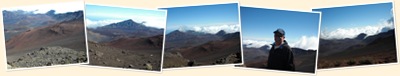
Back up top we take what we are calling the OPL (Old People’s Loop). This is a short little hike up to the top of a rocky mount that gives you excellent views of the crater. We figured its for people who don’t want to or can’t hike down into the crater itself. OPL, ha! This one beats us up too. It’s all up hill with steps to boot. It’s got to be the elevation, but still, it’s a chore getting up there. The views are great – a whole different perspective than being inside the thing.

We come back down, get our stamp at the Visitor’s Center and them head back down the mountain, stopping at all the various lookouts and overlooks. They are all wonderful vistas – and as we continue down the mountain, we see the clouds have rolled into the upcountry.

Normally in the afternoons, the clouds cling to the sides of the Volcano, shrouding most of it from view. Nothing different today – but being up here is really different. We’re above the clouds, in perfectly gorgeous sunny weather. Then we’re driving through them. You can actually touch the clouds! And they are cold! It’s eerie, really. Like a shroud of thick mist that just rolls over you and above you on the winds. Eerie but cool – literally!

We take the long loop back to the valley – and stop by the Lavender farm. this is tourist heaven, but it’s kind of neat. Fields and fields of lavender, a lovely little botanical type garden to meander through (or take a $14 guided walking tour, $14 each that is! Not!). They have a gift shop with lavender coffee (ick) and tea (didn’t try) and all sorts of really pricey lavender candy and cookies. It’s beautiful, so we just soak up the scenery and the weather, then head back down the rutted pothole filled road to the main highway back into the low lands.

Back at home, we freshen up and hit Lulu’s for a sunset happy hour drink. Then home for dinner and a relaxing night after a very full day.


No comments:
Post a Comment