Just like with hurricanes, Tuesday dawns cool and clear as a bell. We are all outfitted and prepared for our day long journey to Hana and beyond – so off we go with our backpack stuffed with suntan lotion, bug spray, hats, water, bags, you name it –and our cooler filled with lunch foods. Hana has notoriously overpriced and mediocre, or even bad, food choices. So we’re prepared to picnic our day away.
All the guidebooks tell you to leave early to avoid the traffic and crowds – of course, we would do that normally anyway – so it’s no big deal to us. We’re on the road at 7:00 and hit the beginning of the winding, curving, mountainous part of the drive by 7:45. We’re following our Maui Revealed guidebook, and after being a little dopey about the mile markers, we eventually begin to find the sights we’ve marked for our drive.
First comes a fantastic waterfall with a pull out “next to a telephone pole and barbed wire fence”. yep – that’s where it was. And you have to bush hog your way down to the path, and step through the barbed wire fence to follow the little muddy path down to the overlook. But it’s worth it. The Lower Puohokamoa Falls are beautiful, made even more fantastic by the fact that we’re the only ones here. It’s sunny, it’s cool, it’s a beautiful day for the Road to Hana!


So – off we go – in search of our next stops – more waterfalls and scenic overlooks. I won’t bore you with all the details, but we followed the guidebook pretty faithfully, and pretty much all of there stops were great- except for the few we couldn’t find or were near construction sites so were inaccessible (the book is 10 years old after all, so it’s pretty amazing that much of this hasn’t changed). Here are the highlights:
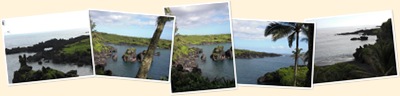
It’s only about 38 miles to Hana from where the mile posts start, but it takes at least 2 hours to get there, and that’s with minimal stops. There are something like 56 one lane bridges and 600 curves on the route 360 part of the Road to Hana (and no, we didn’t count them! I know I’m anal, but I’m not that anal!). Ed did a superb job navigating all the turns, bridges and oncoming local traffic (who, since they are local, drive that road like it’s a straight 2 lane highway! There were a couple of gasps when faced with an oncoming local during our drive – that’s for sure!). I got a little car-sick for a while before Hana – it’s that crazy! But it’s also a glorious drive. Lush, dense foliage, with streams and waterfalls at so many corners. And glimpses of the Pacific way far below you, down steep and craggy cliffs. See below for some miscellaneous photos.


Overlook at Ke’aene
We decided not to detour down to Ke’aene, but to keep heading up the road. It’s a little town, down what appeared to be a dirt road. And while we’re adventurous – we wanted to get to Lindbergh’s grave (which is 10 miles or so past Hana) before the crowds. We did stop at an overlook and take some great pix of the Ke’aene peninsula though.


Hanawi Falls
We soldier on, taking turns at break neck speeds and successfully avoiding rocks on one side of the car and speeding locals on the other. We pass some alleged great scenic overlooks (didn’t see any overlook or the benches we were supposed to park next to), and a couple of places that were good waterfalls, but there’s no place to park – unless you want to ignore all the “No Parking” signs – which on this road? Nah, we’ll be law abiding – and not life threatening. At mile marker 24 though, there is a cute little waterfall – and there’s nobody coming down the road. We hop out and take a few snaps:


Nahiku
Next up is Nahiku – a “quaint little village” at the end of this 2.5 mile virtually one lane road that snakes down the hillside. Supposedly, at the end of the road is a gorgeous vista and a little hiking trail that will take you to an artesian waterfall. We navigate down the road, waving to a tie-dye outfitted long gray haired hippie getting ready to set out on his bicycle – only to find our way blocked at the school bus turnaround. Apparently, the traffic was too much for the locals, because there is a huge sign that say “Local residents only” and road cones blocking the way. Bummer! Nice diversion – but…..
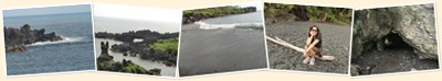
Wai’anapanapa Park
Next stop is the black sand beach at Wai’anapanapa state park. This is much easier to find – although it’s still down a very narrow, bumpy little road. But the road ends in a large paved parking lot, with ranger outpost and facilities. Facilities! There are only a few on the way up, so these are a happy sight.
It’s beautiful here – and we’ve got the place virtually to ourselves. It is SO worth it to come up here early to avoid the crowds. There are trails all through the park, and we head out to the beach and pond loop trail. The beach is wild – black lava sand and rocks, makes for excellent photo ops. It’s cool, with a breeze, and the sun coming in and out of the clouds. Too bad it’s so early, this would have been a perfect picnic spot!
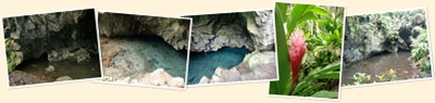
After hanging out at the beach a bit, we hit the loop trail to a cave with a fresh water pool. It’s a great trail, walking you through branches of trees that have grown over the path, so you have to duck or – as you’ll see in the picture below – hang/lean on them like a monkey! The cave is pretty wild – and creepy actually – but the fresh water pool is amazing. It’s crystal clear even today after all the rain. Ancient lore has it that a beautiful princess ran away from her cruel husband and hid here in the cave. His men saw her reflection in the crystal clear water, and the husband dove in and killed her. The water supposedly turns red every year on the anniversary of her death. Fortunately, the anniversary wasn’t today!

No comments:
Post a Comment