Last land day, last day on the islands. We’re looking forward to today, because we are doing something completely different than the usual Volcanoes National Park or the waterfalls tour (we’ve done both a couple times in the past). We are heading south, down into Puna to go to the Lava Viewing areas where we can see the results of the huge lava flow from 1990-1992 that totally overtook the town of Kalapana.
We are close to first off, and out waiting for our shuttle to the airport. We are not having much luck with these shuttles – once again, everyone else is there but Hertz. We must have a curse on us or something. The sweet Dollar guy says he’ll take us over if he has room – but our guy finally shows up last, and loads us all in the van (along with the pushy French Canadians, but we have a strategy – Ed’s sitting in the front seat and he’s just running out first to get in line before everyone else). Turns out its not really a rush – the others are pokey – so Ed is first in line.
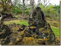
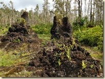
So, a little slow start, but we’re finally in the car and on the road for our big loop tour of the Puna area. First stop is the Lava Tree State Park, that was just reopened in December from the Hurricane that ripped through this end of the island in June of last year. The park has a quick little loop trail that walks you through the lush forest and around the freestanding hardened lava casts of the tree trunks. It’s a nice little diversion and the tree trunks are wild – the lava flow was in the 18th century, so the casts are there and there is new growth all around – including some coming out of the casts.
The storm damage that closed the park is still evident with all the trees that are down, and lying on the side of the trail. There is one tree in particular that is just amazing – the whole root ball is on its side and you can just imagine the power of the storm from that huge tree that was downed.
Next we continue on out to the Red Road, so named because it was originally made of red cinder pavement. This area of the island is so different than the main Hilo town area, and even up north on the coast. The roads are small and narrow, and totally enclosed with vegetation. There is hardly anyone on the road, and it is just like being out in the wilderness alone. Completely different and awesome.
Our destination is the Kapoho Tide Pools, which are located in a little neighborhood by the water. The directions we have says to go and park when you can see the ocean, but when we get to the entrance to the neighborhood, there is a parking lot and signs saying car access is only for residents. So, we follow the signs, park and walk into community. There are little tide pool directional stamps on the road, with an arrow showing you where to go. The neighborhood is cute, smaller houses tucked into the natural lava and foliage landscape. There are some in disrepair, one that appears abandoned and others in really good condition – typical of anywhere here on the islands.
It’s a good 10 minute walk to reach the ocean – but it is well worth it. If we were swimmers or snorklers, this would be a great place to spend the morning – tons of tide pools all along the coast – the info we have says they stretch for 1 mile. So peaceful and beautiful – it would be awesome to have a house right here overlooking the pools.
Navigating back to the car, we pass a few folks headed toward the pools on foot – and the lot is pretty full when we arrive. Back on the Red Road – our next destination is Kaimu beach – the original black sand beach that is covered in 20 feet of lava from 1990.
The road is like something out of a story book. It is narrow with trees closing in on you from both sides. It is also what I call the roller coaster road – peaks and valleys, up and done into dips, what Ed says would be a blast for teenagers to come out here and just see how fast they could really drive it. I’ll pass, I’m happy with the stately pace we’re taking now.
Around mile marker 14, we stop to do a little wave watching from the lava bluff above the ocean. It’s really pounding the coast here, we get soaked just from the spray of the waves.
As we progress further, we pass lava fields on both sides of the road, where you can see how the lava river just streamed down from the volcano. Imagine that sight! We also see lots of those little mongoose animals. They look sort of like a weasel or ferret, and there are lots that are running across the road in front of us (and one that didn’t make it). I have a whole bunch of tidal pools and heated thermal pools on the list to visit, but we blow all those off and head straight for the beach at the end of the road.
And what a surprise that is! We’d read the road ends and you can walk out onto the “new” Kaimu beach at the end of the lava flow – but we didn’t read about Uncle Robert’s Awa bar, food stands and farmer’s market here. It’s crazy busy, with a band playing, tons of cars in the parking lot, people all over with these big tent like structures and vendors outside on the steps up to the lava/beach walk selling jewelry, volcanic stone mortar and pestles and all sorts of coconuts and bananas and things. Wild!
We walk up onto the lava beach trail first, which traverses the lava flow and leads you out to the new beach area. The lava here is mind boggling – first because it is just such a huge flow, and second because this is the flow that cut off and covered over Kalapana. The striations on the lava are fascinating, you can see the layers of lava as they formed and cooled and then heated again. It is sort of surreal to be walking on this now – knowing that when it was active it was a burning inferno of red hot lava slowly creeping its way down from the volcano to the sea.
Down near the beach, you start to see all the new plantings that have been done since the flow. A woman who lived in the community started the coconut plants to try to regrow the vegetation on the lava. She led a group of volunteers who carried on after her death (from cancer) – about a year or two after she started the project.
At the cliffs near the ocean is a little bench made from fallen tree wood. It is a great place to sit and reflect and think about the power of nature and how unpredictable it can all be.


No comments:
Post a Comment